Summit hike Mäggisserhore

GPX

PDF

13.69 km long
Difficulty: medium
condition: medium
Great panorama
Hiking Trail
  • 05:00 h
  • 1,062 m
  • 1,062 m
  • 1,285 m
  • 2,346 m
  • 1,061 m
  • 13.69 km
  • Start: "Hasenloch" car park, Springenboden
  • Destination: "Hasenloch" car park, Springenboden
From Springenboden to Mäggisserhore: discover a true hiking gem on the Niesen chain

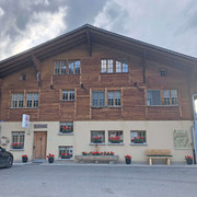
The impressive hike with the destination «peak of the Mäggisserhore» starts at the «Hasenloch» car park in Horboden. If you travel by public transport, the starting point can be reached on foot from the PostBus stop «Horboden, Chirel» in approx. 1 h 30 min. Although the hike begins on an asphalt road, the higher you climb, the more it unfolds as a true hiking gem.

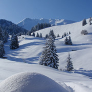
From the alp «Hore», a steep dirt road leads to the alp «Ober Mechlistall». Past the picturesque lake «Mechlistallseeli», a clearly visible hiking trail leads further and further up to the summit of the Mäggisserhore. At the top, you have a breathtaking view of the Diemtigtal Nature Park, the Simmen and Kander valleys, Lake Thun and Lake Brienz and the neighbouring Alpine peaks of the Bernese Oberland, which seem close enough to touch from up here.

Good to know

Best to visit

suitable
Depends on weather

Directions

From the «Haseloch» car park, follow the road on foot, which leads up to the right to Springenboden and then straight on along the only asphalt road to the «Bärgli» alp. Here follow the road to the right in the direction of «Widbodmen» and «Hore». From the alp «Hore», a steep dirt road leads you in the direction of the alp «Mechlistall». Follow the natural road  until you reach the alp «Oberer Mechlistall». From here, a narrow hiking trail leads past the Mechlistallsee lake directly to the summit of the Mäggisserhore.

Equipment

Good mountain boots, clothing appropriate to the weather (sun/rain protection), possibly walking sticks, pocket pharmacy, rucksack with food and enough drinks for the journey

Directions & Parking facilities

Motorway A6 Bern direction Zweisimmen, 1 km after the Simmenfluhtunnel turn left direction Diemtigtal. Follow the Diemtigtal road into the valley for 8 km until Horboden. Turn left here and follow the signs for "Springenboden" to "Haseloch" (5.5 km).
Parking spaces are available directly at the Hasenloch car park or at the Gsässweid Inn.
By train to Oey-Diemtigen station (Spiez-Zweisimmen line). Continue by PostBus to the «Horboden, Chirel» stop. From here the «Haseloch» can be reached on foot (1 h 30 min.).

Additional information

A hiking map is available from the Diemtigtal Nature Park office.

Diemtigtal Nature Park
Bahnhofstrasse 20
3753 Oey
Phone 0041 33 552 26 00
info@diemtigtal.ch
www.diemtigtal.ch 

Author´s Tip / Recommendation of the author

Fancy a delicious snack after the hike? Visit one of the restaurants Gsässweid, Springenboden or Rothbad on the way back.

Safety guidelines

Your hike takes you through a variety of pastures - always keep your distance from the four-legged alpine inhabitants. Especially on the last section of the hike you need a little head for heights.

Nearby

Getting there
Summit hike Mäggisserhore
3755 Diemtigen